


A Geographic Information System is a computer based technology consisting
of hardware, software, data and applications. It allows capturing, editing, storing, reorganising, modelling and analysing all forms of geographically referenced information. With the help of GIS, data can be interpreted and visualised in many ways that reveal relationships, patterns and trends in the form of maps, reports and charts.
Article about GIS (Wikipedia)
Guide for GIS (ESRI)
What is GIS? (USGS)
What is GIS?
This chapter briefly describes the benefits, objectives and application spectrum of Geographic Information Systems (GIS) to give you some helpful background information regarding the Open Source DesktopGIS gvSIG.
GIS Definition
 |
Usage of GIS
The usage of GIS offers many benefits and can become an important
part in project management. Geographic Information Systems are used in many different fields,
e.g. in natural science, cartography or geography, urban or emergency
planning, navigation and far more.
Benefits and Organisation of GIS
With the help of GIS, spatial data can be explored and analysed fast and easy and can be organised in a global
database. Using GIS allows accessing this global database to work with just one homogeneous dataset
without distributing every single dataset to an own GIS personal computer. Furthermore, you can combine data from different
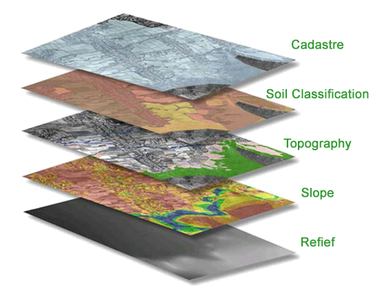
sources and formats as well as transforming data files into one standardised Spatial Reference System. DesktopGIS solutions work to the rule of layer principle. Thus, geographic information is organised in different layers, one lying hierarchical on top of another (as demonstrated in the graphic above). |
 |
Application spectrum of GIS
"Finding the correct location for the construction of solar panels",
"Locating rivers that need to be protected from pollution“, "Mapping of areas or project sites, as for example wells" or "Importing and organising GPS-Points into a database" are common issues where GIS could be applied to support planning and decision making. |
 |